
Woodlands Cemetery Survey – 2008
Lot 2, Plan BCP8786.
Ian Walker, BCLS
The first step was to accurately draw the cemetery grid from drawing 77-13-6 produced by the Department of Public Works Office, Essondale.
Initial Drawing Assumptions:
1. An individual cemetery plot size of 4' x 8' and,
2. all walkways 4' wide,
3. produced an initial cemetery size of 620' x 192'.
Digital Drawing:
The cemetery was divided into 4 foot "units".
This created an easterly length of 620 feet (151 units + 4 walkways)
And a northerly width of 192 feet (41 units + 7 walkways)
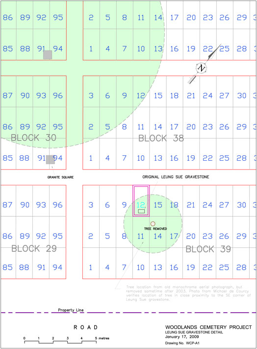
It was on this basis that the linework for the individual cemetery plots were digitally recreated in Autocad and annotated with the "Block" and "Plot" numbers shown on Essondale's Plan number 77-13-6.
Field Survey:
Field surveys were undertaken by Ian Walker & Michael de Courcy. The primary purpose was to accurately measure the positions of the remaining original gravestones and cadastral monuments in order to adjust the "assumed dimensions" of the digital cemetery drawing to real ground measurements. This was accomplished by creating a local survey network with a Sokkia total station and measuring existing gravestones, new memorial stones, pathways, trees and cadastral monuments. This data was recorded over three site visits and the resulting coordinates were downloaded into the autocad drawing using a TDS Ranger data collector. Elevations were not included since we were only interested in horizontal positioning.
Adjusting the Digital Drawing to fit the Field Survey:
The coordinates produced from the field surveys were used to correct the digital cemetery drawing for rotation and scale as well as referencing the coordinate positioning in the NAD83(CSRS) UTM Zone 10 mapping framework. Coordinate values created for each grave site will enable anyone with a suitable hand held mapping grade GPS receiver to locate a grave site within a few metres.
(1) Rotation for the cemetery grid was made parallel to the directional bearing of the cadastral north boundary of the cemetery defined by Lot 2, Plan BCP8786.
(2) Scale factors were calculated and applied independently to the orthogonal northerly and easterly distances of the cemetery drawing to match the original Murphy & Leung stones as follows:
_090121.jpg)
Calculating the scale factor for the easterly distance between Murphy & Leung stones:
Easterly Scale factor = 423.8 ft (surveyed) / 444.0 ft (calculated) = 0.955
Overall cemetery length = 0.955 x 620 ft = 592 ft
Calculating the scale factor for the northerly distance between Murphy & Leung stones:
Northerly Scale factor = 92.9 ft (surveyed) / 104.0 ft (calculated) = 0.894
Overall cemetery width = 0.894 x 192 ft = 172 ft
Overall size of the cemetery after adjustment to field survey
= 592' x 172' = 101,824 sq. ft (2.3 acres)
As a result of these adjustments, an individual cemetery plot is approximately 4 ft x 7 ft.
(3) Positioning in the UTM mapping projection was referenced to the integrated survey monument 89H6084 set in southerly edge of the service road near the Arenex of Queen's Park. Cadastral boundaries of the cemetery were referenced by two iron posts found and measured as shown on Plan BCP8786 and BCP24033.
Aerial Photo:
Digital ortho rectified aerial photo was supplied by McElhanney Surveys. This photo was geo-referenced to the UTM mapping projection and imported directly into the drawing using Autocad Map and associated world tif files.